Border Ranges National Park: Jan and Peter (both 74) took to their caravan to explore.
BORDER RANGES NATIONAL PARK
The World Heritage-listed Border Ranges National Park has scenic walks and breathtaking views surrounded by ancient landscapes. We took off in our caravan for a break inside the Gondwana rainforest.
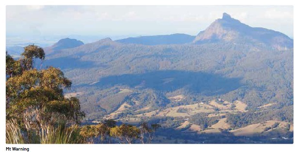
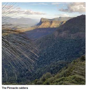
Mt Warning is a dominant feature of the Tweed Valley in Northern New South Wales. It sits in Wollumbin National Park. This remnant core of a volcano was active 23 million years ago. Today, the core is less than half its original size. The surrounding caldera once covered an area of 80 x 100 kilometres. The erosion activity over the past 20 million years created a large cauldron- like landscape. It has one of the highest levels of biological diversity in Australia.
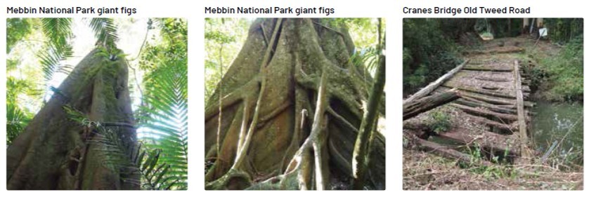
Mebbin National Park sits inside the caldera rim. We spent our first evening camped in this National Park. We travelled there along the Tweed Valley Way then via Murwillumbah, through the quaint village of Tyalgum, Brays Creek and pot- holed Byrrill Creek Roads to Cutters Camp. The campground, in a cleared forest setting, has recently been refurbished. New barbeques, picnic tables, toilet facilities and fireplaces have been installed to a very good standard. We enjoyed having the whole area to ourselves, (perhaps because it was cold.)
An upgraded walking track winds around a two-kilometre loop to Sweetmans Creek and back along the edge of Byrill Creek. It passes through subtropical rainforest between giant, ancient fig trees. In the late afternoon red-necked pademelons grazed happily on the grass close by.
LOCAL LEGENDS
An elderly farmer in the area caught our interest in an area further to the west near Wadeville. He shared legends and stories from the turn of the century when timber getters wandered the lands. They worked in the forests, winding their way with bullock teams to harvest the giant forest logs. There were stories of blood-stained floors and family feuds. It was late in the day when we ventured along the track that is the Old Tweed Road. It was here that a bullocky was murdered with a blow from a bullock yoke. And that wasn’t the only ghost that haunts the area.
A German settler, spurned by the one he loved, shot himself. Halfway along the track, the crumbling wooden Cranes Bridge carries a legend of an apparition that appears on the bridge. The late afternoon breeze created moving shadows across the rough track, creating an eerie feeling. We hoped a ghost of the past would linger but alas, none visited us.
A short distance away at Hanging Rock Bridge on Barkers Vale Road, incidents from the past have also added to local folklore. Apparently, a local businessman from the past abandoned his journey along this road when an apparition appeared on that bridge. A Nimbin village resident reported that his reliable horse refused to set a hoof anywhere near the bridge. We were disappointed to see that the old bridge had been replaced with a new model. But we were able to view the original crossing of the river. The mournful hoot of an owl and the approaching evening caused us to move on.
NIMBIN
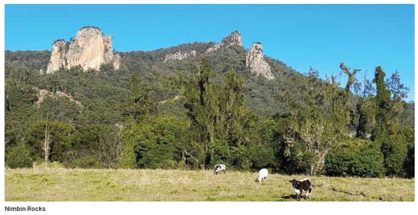
The showground at Nimbin was a convenient next campsite with plenty of space and clean facilities. The village, overlooked by impressive rock formations, is a central base for exploring the natural wonders nearby. Forests of red cedar first attracted timber getters to the area in the 1840s. The 1973 the Aquarius Festival brought alternative lifestylers and communes sprouted up in the surrounding hills. The streets of the village are predominately named after the early farmers, mostly in the dairying industry.
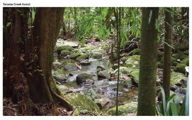
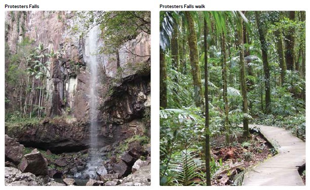
A nearby excursion was via the village of The Channon and along a fifteen-kilometre (part gravel) diversion leading to Protesters Falls. In 1975 local residents Nan and Hugh Nicholson raised the alarm when they discovered the logging plans for the area. The Terania Creek Protest was organised in 1979 against logging old growth forest. While the original protesters’ intentions were non- violent and peaceful, not everybody supported that ideal. However, this was the first-time people physically defended a natural resource. The mill was closed down as a result. The New South Wales Premier at the time, Neville Wran, made the historic ‘Rainforest Decision’ in October 1982. It saved approximately 100,000 hectares of forest from harvesting.
The picnic ground offered a pleasant venue in the rainforest for our lunch before a one- and-a-half-kilometre walk. It followed along the pretty Terania Creek through Bangalow palms to eventually emerge at the base of the impressive long drop of the falls and pool. This is the home of the endangered Fleay ’s Barred Frog. No swimming is allowed.
MT NARDI
Our original plan was to hike the Pholis Gap and Mt Matheson Loop starting from Mt Nardi in the west Nightcap National Park. This is the starting point for several walking tracks including the Historic Nightcap track. This was once the principal route taken by travellers and postal workers in the 1870s between Lismore and Murwillumbah. The journey required an overnight camp hence the name “Nightcap.” With pack horses, the mailman took three days to travel the muddy track. Today, the mountain can easily be identified by the television transmitting tower on its summit.
Mt Nardi was named in memory of Terania Shire Councillor Angelo Nardi (born in 1899) for his services to the community of Nimbin. He was a descendant of the pioneer farming settlers of New Italy – now a historic rest stop on the Pacific Highway. Pholis Gap received its name in memory of Athol Pholis, a timber worker, who was killed on the track by a falling tree.
We were disappointed to find the access road leading to the commencement of the Nightcap track at Mt Nardi closed for repair. However, we made a booking at Rummary Park campground where we could access part of this historic track from the south-east end. We were delighted to find another upgraded National Park camping ground. And, once again we had the camping area to ourselves. We expect the low temperatures kept away all except us hardy campers.
CECIL C.JONES CABIN
A cabin in the campground commemorates Cecil C. Jones who was a forest foreman in the Whian Whian Conservation Area. He lived there in the red mahogany cabin with his wife and four young children. It is the last remaining cabin of the ones constructed during late 1940 and early 1941 by the Forestry Commission in this forest setting, then named Boggy Creek camp. A cottage was also constructed for visiting for VIPs, especially the Forester in Charge of the Whian Whian area – Tom Rummery. The campground is named after him. Tom and Cecil planted a big kauri pine which can still be seen there today. When Cecil died in 1993, the Forestry Commission installed a memorial plaque with the words, “the bush has friends to meet him and their kindly voices greet him.”
Our hike the next morning was a grade three, six-kilometre return hike to Peates Mountain. It went through forest which is regenerating after recent bushfires. It was a steep climb towards the summit. Disappointedly the tall eucalypts at the top blocked what could be a spectacular view to the coast. We enjoyed a packed lunch before hiking back to camp along the historic Nightcap track. Unfortunately, the Boggy Creek walk from Rummery Park to Minyon Falls was also closed for maintenance. However, before moving on the next morning, we explored the Blue Fig Track for a couple of kilometres. We relaxed by a pretty cascade and watched a pair of Rufous Scrub-Birds fossicking in the dense eucalypt forest.
BORDER RANGES NATIONAL PARK
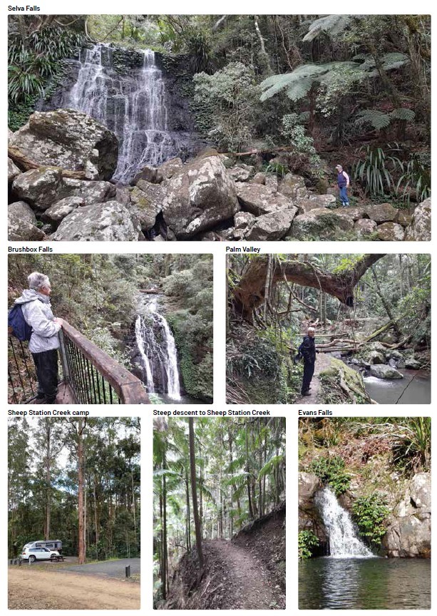
Our journey continued via Kyogle and Wiangaree (the eastern access road was closed) to the Border Ranges National Park. The 44-kilometre gravel Tweed Range Scenic Drive travels along the elevated edge of the caldera of the Mount Warning volcano, affording stunning views from the lookouts. This dramatic escarpment is the rim of one of the largest calderas in the world. Sheep Station Creek campground, a large area also recently refurbished, was our campsite for a few days. It is well set up with large campsites for vans and tents. We enjoyed the numerous hikes in the area.
From the campground, we hiked through eucalypt and rainforest for 2 kilometres to lovely Brushbox Falls and Palm Forest. Following the line of an old logging and bullock trail across the creek, we came across a sandstone rockface where early loggers carved their names. Beginning in 1886 the Red Cedar was harvested from the plateau with bullock teams. The bullock wagons were unloaded on the hill and taken empty around the steep descent to Sheep Station Creek. The sandstone rockface was used as a reloading ramp. Logs were hauled to the Richmond River where they were floated downstream for shipment. We continued on for 4 kilometres, connecting up to The Rosewood Loop circuit in old-growth Rosewood and Flooded Gum trees.
BRINDLE CREEK WALK
Because the Brindle Creek Walk is 6km one way and not a loop, we decided to hike it in two sessions. We parked the car at the Brindle Creek picnic area. We followed the line of Brindle Creek through lush rainforest for a five-kilometre return hike to Evan’s Falls and pool. Swimming is not recommended in the creek as it is also a habitat for endangered frogs. It was a pleasant spot to enjoy our lunch. Before returning to Sheep Station Creek campground, we drove further on to The Pinnacle Lookout. The short walk to the viewing platform revealed a view 1000 meters below into the Tweed Valley and across to the rugged volcanic core of Mt. Warning. It is stunning!
On our final morning, after morning tea in the Antarctic Beech picnic ground where we left our vehicle, we hiked 6 kilometres return. It was through huge hoop pines and large Antarctic beech trees to Selva Falls, again on the Brindle Creek walk. It was an uphill climb back to the picnic ground.
Back at Sheep Station Creek we hitched up the van to commence our homeward journey. We were reluctant to leave after spending a very enjoyable week of staying and hiking in these ranges. We decided this area has some of the best views and walks in New South Wales. But, the Gold Coast was calling us back!

Editor for Silver Magazine Gold Coast